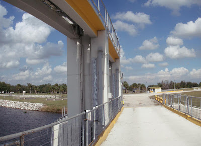
Dec 31, 2008

S333

Today is the final day of 2008.  So yet again, we pass through the door (or in this case, water gate) into a new year.

Dec 30, 2008

Under a live oak


This walkway had some big live oaks, with lots of spanish moss. Photo was taken at Patterson Park in central Florida.

Dec 29, 2008

Deer Creek bend

Here's a bend in Deer Creek, a tributary of the Susquehanna River, in Maryland, just upstream of the US Geological Survey flow monitoring station.

Dec 28, 2008

Bridge of peace


I walked across that bridge, open to foot traffic only. That made it a peaceful walk.

Dec 27, 2008

Peaceful bend


Bend in the Peace River at Arcadia.

Dec 26, 2008

Valencias?


Actually, I think these may be the Florida navel orange. Florida has the best juicing oranges no matter what the variety.

Dec 24, 2008

Top of the world


Another view from high up in the Alps, at the top of the watershed. Last three photos are courtesy of Martin Pfaundler.

Dec 23, 2008

Down glacier


In fluvial river systems we say "down stream," but in this photo we are looking "down glacier."

Dec 22, 2008

River of ice


An Austrian colleague of mine lives and works in Switzerland. This photo of a glacier perched high up in the Alps is a reminder that water flows even in its solid state.

Dec 21, 2008

Soaking in wave


This wave broke up on the low tide beach. It showed some signs of life before soaking in and draining back into the gulf.

Dec 20, 2008

Low tide twilight


One of the best times to be at the beach is near sunset during a low tide.

Dec 19, 2008

Naples sunset


It's getting closer to the shortest day of the year. But not yet.

Dec 17, 2008

Navigational light


This light helps boats steer into the lock channel.

Dec 16, 2008

Lock and dam


Here's a panoramic photo showing both the lock and dam, looking north (upstream).

Dec 15, 2008

Lock view


Here's a closer look at the S65E lock. No boats passed through on the day I was there.

Dec 14, 2008

Looking back


This photo was shot standing on the dam, looking back towards the lock. You can see the lockhouse in the background.

Dec 13, 2008

S65E dam


Here's a photo of the dam, on the upstream side.

Dec 12, 2008

S65E lock


Here's a photo of the S65E lock, looking downstream (south).

Dec 11, 2008

Kissimmee River


The S65E is the downstream-most structure on the Kissimmee River, on its way down into Lake Okeechobee.

Dec 10, 2008

Multi-humped dome


This "multi-humped" cypress dome caught my eye from the helicopter. It's ringed at its perimeter by a continuous stand of pinelands. That ring of pines really jumps out now that the cypress have lost their needles and turned gray for the winter.

Dec 9, 2008

Old oil access road


Not too far from the old logging tram is another elevated grade that runs for 3 miles from Turner River Road toward Deep Lake Strand. It's an access road to an oil production pad that is no longer in operation. Today it's used as a hiking trail.

Dec 8, 2008

Old logging tram


The linear feature is an old logging tram located in the western edge of Big Cypress National Preserve. It connected State Road 29 to Deep Lake Strand where all the big trees were.

Dec 7, 2008

Turner River Road


Another view of Turner River Road, in Big Cypress National Preserve. When this photo was taken in late November, the wetting front had dropped below the pinelands, but you can still see standing water in the deeper cypress and marshes.

Dec 6, 2008

Not to be confused


No, this isn't another photo of Kissimmee Prairie State Preserve. It's a photo of Big Cypress National Preserve. Turner River Road to be exact.
.
There is a Kissimmee Billy Strand in Big Cypress National Preserve, if that counts.

Dec 5, 2008

Perfect sky day


Another view of the Kissimmee Prairie. It was a perfect sky day for photographs. You don't usually get that in November in south Florida.

Dec 4, 2008

Entrance road


Another view of Kissimmee Prairie State Preserve, along the main access road into the preserve.

Dec 3, 2008

Kissimmee Prairie


I was surprised to see how much the Kissimmee Prairie resembled Big Cypress National Preserve's wet prairies.

Dec 2, 2008

Nov 30, 2008

Wet prairie


In some places the cypress are stacked tightly against one another. In other areas, as shown below, they are few and far in between. We call those areas our wet prairies.

Nov 29, 2008

11 Mile Road


This photo was taken in the eastern half of Big Cypress National Preserve looking north toward the Raccoon Point pinelands. You can see them in the background where the cloud shadow is.

Nov 28, 2008

Hat rack cypress


The dwarf cypress are sometimes referred to as hat racks because they resemble the size and shape of an old time hat rack. You don't see many hat racks any more. My grandparents had one at their front door. Maybe they are more common up north in "jacket and hat" country.

Nov 27, 2008

Cloud reflection


In the air, during late fall, when the cypress needles have fallen, and the swamps are still holding water, the reflections of sunny sky and clouds give the land a three dimensional feel.

Nov 26, 2008

Cloud shadow


As a hydrologist, I am always tracking the ecologic position of the wetting front. That's not what this photo shows. Rather, its a cloud shadow moving across the cypress plain. If you look closely you can see some egrets and even standing water at the feet of the cypress.

Nov 25, 2008

Pines and cypress


In this photo you can see the contrast between the "evergreens" of the pinelands from the needle-less expanse of cypress.

Nov 24, 2008

Deep in the swamp


View of a cypress dome, in winter, from the ground. November is the first official month of the dry season ... but November is also just on the other side of our peak water season, so water is still covering most of the preserve.

Nov 23, 2008

Annual needle drop


Up north the leaves have already started to fall from their branches. The same thing happens in the Big Cypress Swamp to our cypress in November. When it happens, the pine islands, which remain green, really jump out.

Nov 22, 2008

Bon voyage


Another happy customer, heading downstream from the lock.

Nov 21, 2008

Empty lock


This photo nicely shows how far the boat had to drop to get from one side of the lock to the other. That makes me wonder: what's the drop on other major locks in our nation's river system?

Nov 20, 2008

View from the lock


View of the S78 Dam from the edge of the lock, looking south. There was just the right dose of cloud cover for good photos on this day.

Nov 19, 2008

Gates


The lock gates are bigger than you'd think, and they have to be strong. Water is a mighty force.

Nov 18, 2008

S78 headwaters


Here's the upstream side of the S78 spillway. You can see the lock master's house in the background, on the right.

Nov 17, 2008

Closed lock


Here's a photo of the same lock, looking downstream, when it was closed. On that day there was a significant drop in river stage on the upstream and downstream side, on the order of around 10 ft. That made it fun to watch the boat pass into, and through the lock, as the lock keeper with the Army Corps of Engineers slowly let water out of the chamber through the downstream gate.

Nov 16, 2008

Ortona lock


Here's a boat entering the lock of the S78, also called the Ortona Lock and Dam, floating down the river.

Nov 15, 2008

S78


This photo was taken in November of last year, looking upstream along the Caloosahatchee.

Nov 14, 2008

Yellowstone Lake


Yellowstone Lake is the largest freshwater lake above 7,000 feet in North America. It covers 136 square miles and has an average depth of 140 ft. Lake Okeechobee is around 730 square miles and has an average depth of 9 feet in comparison.
Thanks for the great photos Alexis!

Nov 13, 2008

Lamar Valley


Lamar River as viewed from Specimen Ridge, also in Yellowstone National Park.

Nov 12, 2008

Winter "water" land


Firehole Falls ... in winter.
Photo submitted by Alexis Brooks.

Submit your photos!

Submit your watershed photos to robert_sobczak@nps.gov. Please include your name, a brief caption, and when the photo was taken.